Low cost
sensors network
Real time
noise monitoring
Download our app
to measure noise levels
The QUIES project
The QUIES project consists of a network of low cost acoustic sensors, installed in a portion of Turin's city area. This network is able to make a persistent acoustic monitoring and can transfer the information to a centralized database.
These measures are shown on a map in real time, allowing the user to depict noise trends over different time periods (daytime/nighttime, weekly, on specific dates).
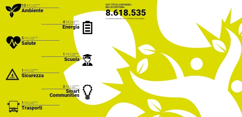
Measurements are available in open format on the big data platform Smartdatanet, for further processing by third parties.
This project involves citizens through their smartphones, thanks to a special app for noise-detection and geolocation.
Features
Sensors network
Our project has developed a capillary network of low cost sensors, that has been scientifically validated in terms of reliability for the detection of enviromental noise.
Read moreCrowdsourcing
Our App for smartphones allows citiziens to use their mobile devices as instruments, sufficiently accurate for noise levels detection, according to the crowdsourcing model.
Read moreOpen data
Collected data are exported to the Smartdata platform, which interconnects applications and objects distributed on the territory. The collected data and information are available for further processing and advanced analysis.
Read moreSound map
Data collected by sensors and smartphones are used to generate a noise map, using predictive analysis and interpolation models.
Read moreSensors network
The monitored area has been defined in collaboration with the Environmental Protection Agency of Piedmont Region (ARPA) and the municipality of Turin.The selected area is densely populated and contains various types of urban elements:
- Historical buildings, such as the "Palazzo Reale", "Palazzo Madama", the State Archives or the "Galleria Sabauda".
- Cultural centers, such as the "Teatro Regio" and University.
- Shopping areas and tourist attractions.
- Areas interested by late night activities, such as Vittorio Veneto square and the "Murazzi"
- Quiet areas (the "Giardini Reali").
The total area amounts to 0.617 square kilometers, with a perimeter of about 4 km (3.94 km). According to the proposed areas, we have chosen 22 fixed locations, which are monitored by two weekly measurement campaigns.
The sensors's position within the territory is shown on the map below. Each sensor is represented by a marker: by clicking on each marker the last ten records kept by the sensor will be displayed in real time.
Crowdsourcing
Every person that owns a smartphone can participate in the noise acquisition phase. Participants must download the QUIES application, available for Android and iOS platforms in the respective stores.
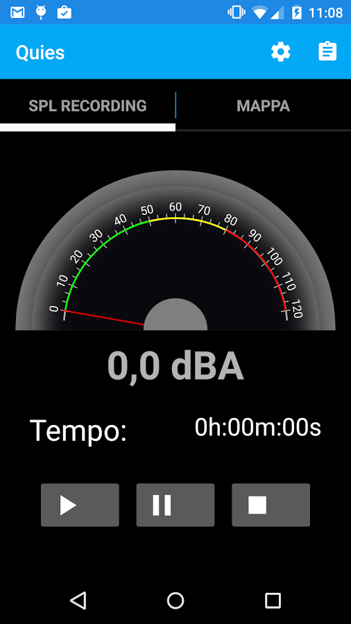
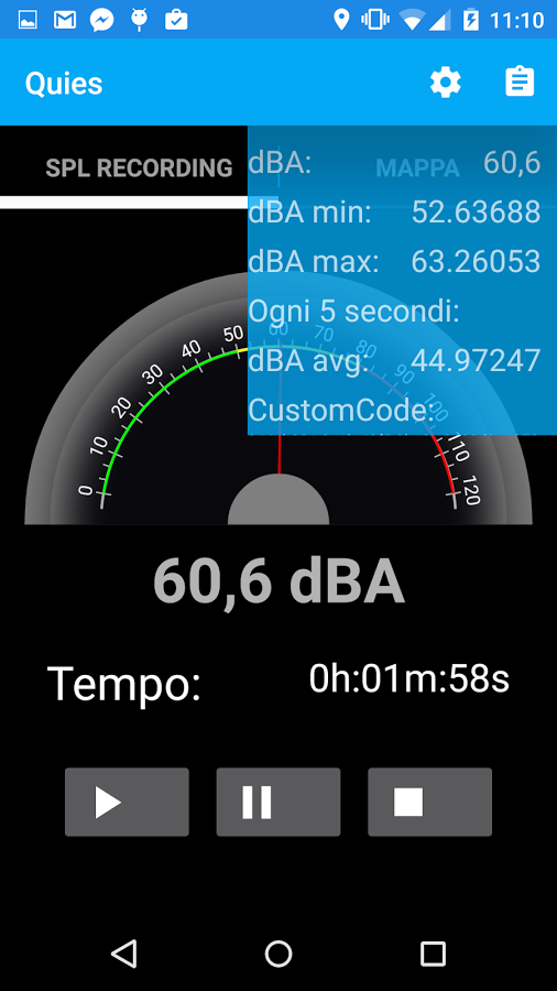
By clicking on the "Play" button it is possible to observe the noise level that is being measured by the device in real time. Measurements are sent to our server every 5 seconds. The application requires an active data connection and geolocation (GPS).
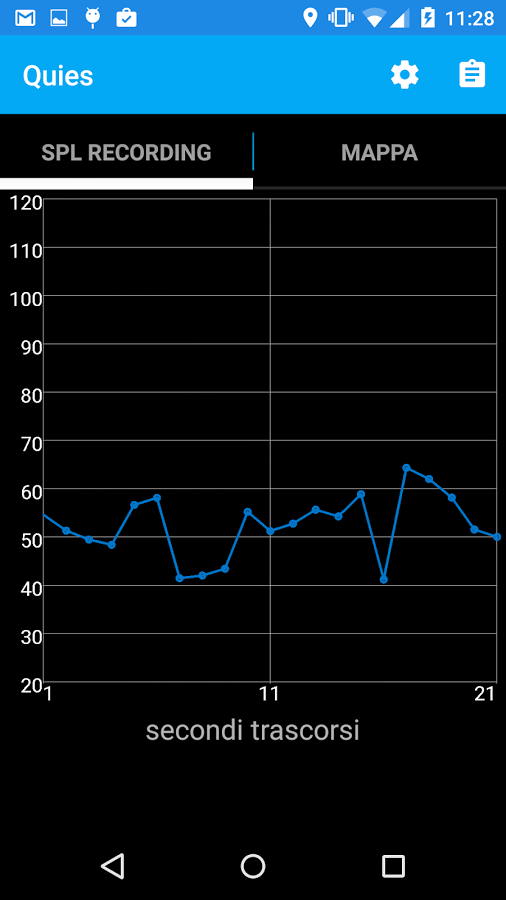
- A cartesian graph, that presents measurement time (x-values) and measured sound level (y-values).
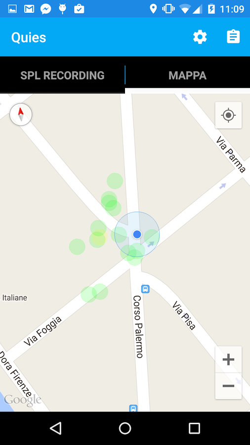
- Interactive geographical map, which represents measurements with circles of different colors, according to noise's intensity.
Open data
Measurements are sent to Smartdatanet, a platform that allows to aggregate and share information from different monitoring services. Collected data flow can originate from:- Internet of things (IoT), such as monitoring videocameras, traffic sensors, weather stations.
- Internet of people (IoP), such as posts on social networks, tweets, blogs.
The platform targets public and private organizations that are interested in sharing their data and developing new applications, with the goal of creating and developing intelligent and sustainable communities.
Sound map
Basing on data that were collected and used for developing the noise map modeling software, using reverse engineering, we have realized a graphical interface for visualizing maps with areas that are enclosed by the defined isophones.
Documentation
Description of the Smartdatanet platform, its specifications and its targets. (italian only)
DownloadDescription of the adopted procedure for integrating QUIES project with Smartdatanet platform. (italian only)
DownloadPresentation of QUIES project for Turin municipality (italian only).
DownloadPartners
Are you ready to participate?
Download our App!


Project funded under the POR FESR 2007/2013 of the Piedmont Region with the assistance of community FESR resources, the Italian State, and the Piedmont Region.